

On the Schanz: The Calm Before the Collapse

Reader's Notice: The end of this article contains an important legal notice outlining the legal framework applicable to its publication, including the protection of freedom of the press and whistleblowers under European Union law.
Latest Update!
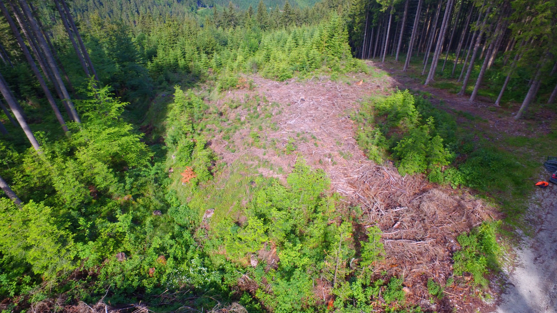
As previously mentioned, we collected soil samples directly from the site, which were subsequently analyzed by a world-leading laboratory. The results are absolutely alarming!The official laboratory report from ALS Global confirms massive chemical contamination of the protected mountain environment, serving as an acute warning of a catastrophic landslide. These hard scientific facts stand as an irrefutable verdict on the illegal activities of the Krenn family. In this pristine nature at an altitude of 1,200 meters above sea level, these substances have no natural origin whatsoever. Their presence proves only one thing: the continuous, massive discharge of untreated commercial catering wastewater through the fictitious "System Dr. Renner" treatment plant.
⚠️ Chemical Catalyst for Disaster: Hazard Zone Extending to Kindberg
- Surfactants (0.53 mg/kg) acting as a liquid lubricant: Synthetic chemistry from industrial dishwashers acts as a lubricant between the layers of the unstable slate bedrock (Birkfeld quartz-phyllite), completely eliminating the soil's internal friction.
- Fats, oils, and hydrocarbons (234 and 240 mg/kg): Enormous concentrations of discarded cooking fats and mineral oil residues (C10–C40) have thoroughly saturated the subsurface, destroying the forest's delicate root systems that previously provided mechanical stability to the slope.
- Destruction of soil buffering capacity (pH 7,1): The highly alkaline chemistry has completely neutralized the naturally acidic forest soil—providing undeniable proof of the long-term, illegal dumping of millions of liters of waste.
Due to this continuous chemical decomposition, the entire precisely measured area of 10,318 m² (over 1 hectare) has transformed into a fully saturated, liquefying mass with an estimated weight of 144,452 tonnes. With a critical slope angle of 22.7° (nearly a 42% incline), this is no longer the risk of a minor, localized shift.There is an imminent threat of a massive mud- and rockslide (debris flow), whose destructive gravitational path would tear through the entire valley, strike residential homes, cut off strategic access to the wind farm, and devastate a 16-kilometer corridor all the way to Kindberg! The entire slope mass is chemically liquefied several meters deep and is ticking like a highly volatile time bomb directly above the heads of the citizens in the valley.
Schanzsattel is a mountain saddle located at approximately 1,160 m above sea level in Styria, Austria.
Recent field observations, terrain analysis, historical aerial imagery and hydrogeological data have raised questions regarding groundwater circulation, wastewater management and slope stability in the area.
This article documents the available evidence and explains why several independent observers believe the locality deserves a detailed hydrogeological and geotechnical assessment.
High in the mountains of Upper Styria, on the border between the municipalities of Fischbach and Stanz im Mürztal, lies Schanzsattel – a remote mountain pass situated at an elevation of approximately 1,200 metres above sea level.
At first glance, the area appears peaceful. A handful of houses are scattered across the slopes, surrounded by forests, mountain meadows, springs and small watercourses that have supplied local residents with drinking water for decades.
Yet beneath this tranquil landscape lies a hydrogeologically complex environment.
The area is characterised by fractured metamorphic bedrock, numerous springs, seepage zones and steep slopes descending towards the Mürz Valley. The highest parts of the investigated area reach approximately 1,166 metres above sea level, while the terrain drops by almost 600 metres before reaching the valley floor near Kindberg.
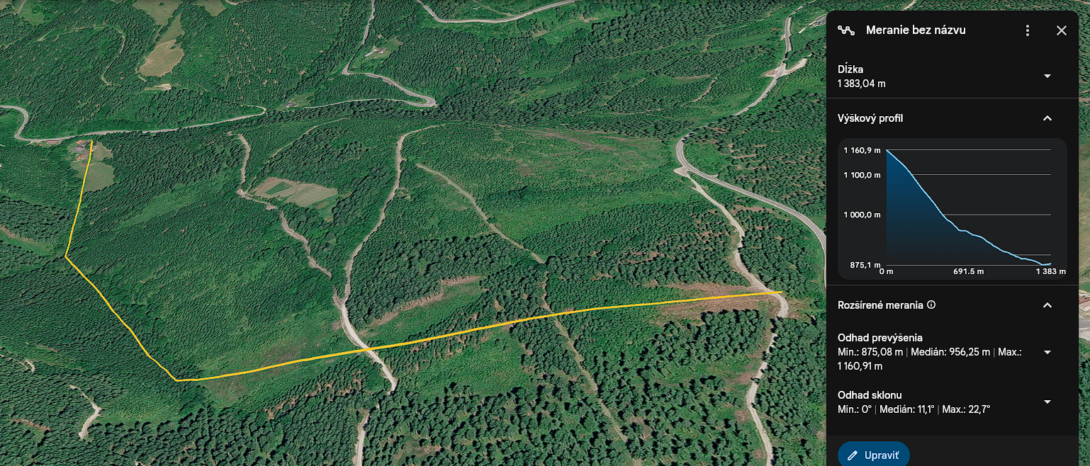
The nearest inhabited buildings are located downslope from the area under investigation. Although the road distance exceeds three kilometres, the direct gravitational path between the upper slope and the first residential properties is only about 1.38 kilometres, with an elevation difference of approximately 286 metres.
It is within this mountainous environment that a series of questions has emerged regarding water management, wastewater treatment, slope stability and long-term environmental monitoring.
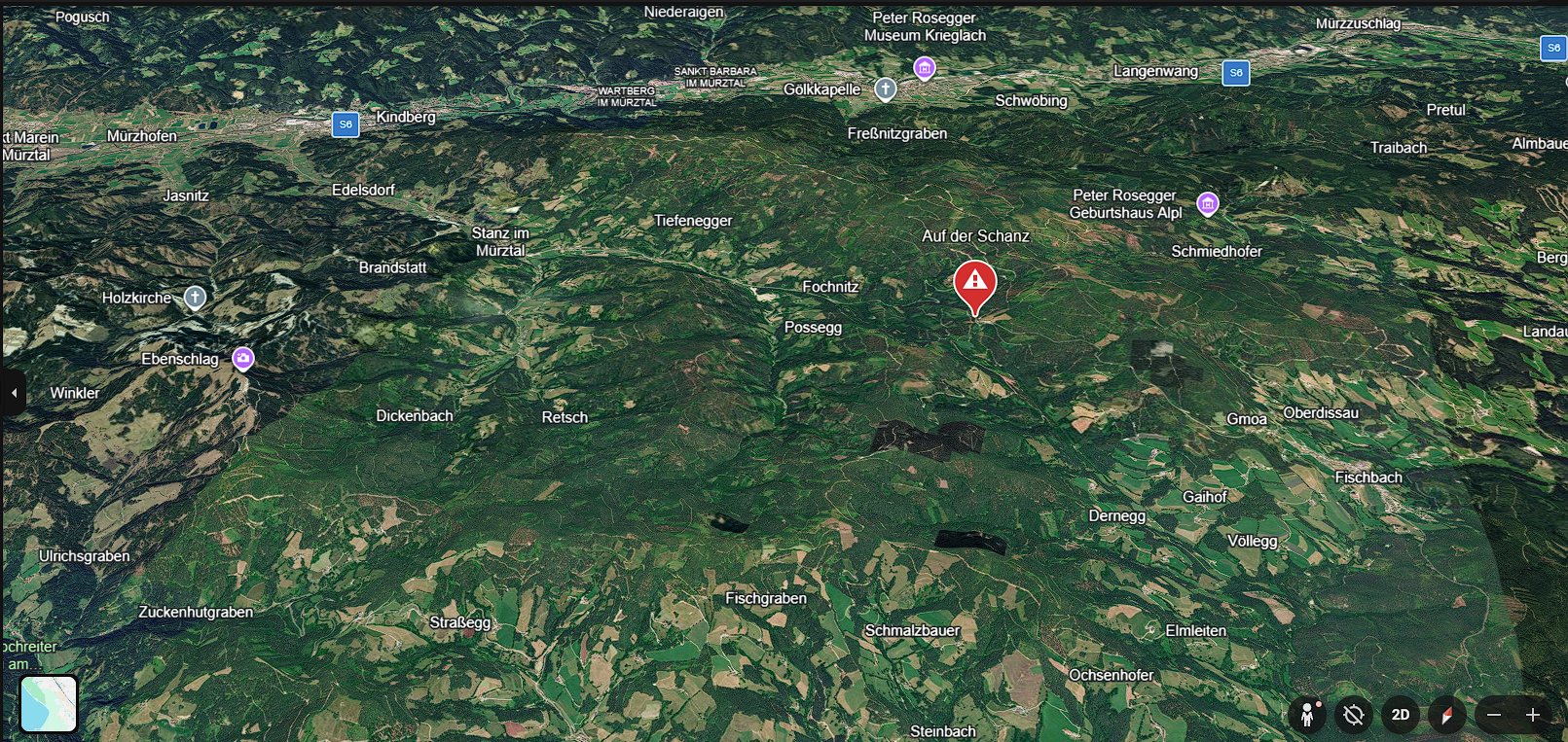
Figure 1. Regional overview of the Schanzsattel area in Upper Styria (Austria). The highlighted location is situated at approximately 1,166 metres above sea level on a mountain ridge between Fischbach and Stanz im Mürztal. The surrounding terrain drains toward the Mürz Valley, where several settlements and transport corridors are located.
A Story of Water, Slopes and Unanswered Questions
Today, we submitted a request to the court seeking the revocation of a preliminary injunction that currently prevents us from publicly discussing issues related to water quality and wastewater management at Schanzsattel.
Why?
Because newly obtained data, field observations and historical records raise questions that deserve answers.
This is not a dispute between neighbours.
It is not a personal conflict.
It is a question of whether a hydrogeologically sensitive mountain area has been monitored with the level of attention its geology requires.
And whether warning signs have been overlooked for decades.
Lessons Written in History
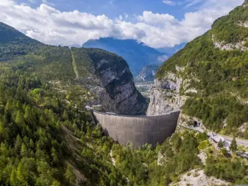
The Alps have witnessed tragedies that forever changed the way Europe views environmental risk.
In Vajont (1963), nearly 260 million cubic metres of rock slid into a reservoir, generating a wave that destroyed entire communities and killed almost 2,000 people.
In Stava (1985), the collapse of mining tailings dams released approximately 180,000 cubic metres of mud, killing 268 people and devastating the valley below.
Neither tragedy happened without warning.
In both cases, warning signs existed long before disaster struck.
The problem was not the absence of signals.
The problem was that the signals were ignored.
A Water System Left Largely Untouched for Decades
For many years, residents believed their spring water system was functioning properly.
Water quality tests were carried out from time to time, but available documentation suggests that the technical condition of the entire system—including pipelines, spring capture structures and protective measures—was not comprehensively evaluated for approximately 36 years.
That fact alone changes the perspective.
What may once have appeared to be isolated concerns now raises legitimate questions about long-term oversight and infrastructure management.
The Wastewater Questions
Years ago, complaints reportedly emerged regarding wastewater handling at a mountain guesthouse located above the area.
Authorities eventually required the installation of a modern biological wastewater treatment system.
On paper, the issue appeared solved.
In the field, however, several observations have raised new questions.
Investigators documented:
- persistent odours,
- waterlogged sections of slope,
- dark surface deposits,
- recurring seepage zones,
- altered drainage patterns.
These observations do not prove any specific cause.
They do, however, justify further investigation.
Scientific investigation exists precisely for this purpose: not to confirm assumptions, but to determine facts.
What the Landscape Reveals
Historical aerial imagery from 2009, 2012, 2013, 2024 and 2025, combined with drone surveys and GIS analysis, revealed noticeable changes in parts of the slope.
The original drainage corridor that attracted attention years ago appears relatively stable.
More recent changes seem to be occurring elsewhere.
This does not prove a connection to any particular infrastructure.
Yet the timing raises questions worthy of professional examination.
Independent Laboratory Testing
To better understand what is occurring within the slope, soil and sediment samples are being submitted for analysis by ALS Limited, one of the world's leading environmental laboratory networks.
The analyses focus on:
- petroleum hydrocarbons,
- mineral oils,
- technical lubricants,
- industrial and anthropogenic contaminants.
The objective is straightforward.
Not to prove a theory.
Not to accuse anyone.
Simply to determine whether substances are present that would not normally be expected in a natural mountain environment at approximately 1,200 metres above sea level.
If contamination is not found, that result is important.
If contamination is identified, further questions will naturally follow.
A Short Distance, A Steep Descent
Measurements indicate that the area under investigation lies at approximately 1,166 metres above sea level.
The first inhabited buildings are located downslope.
While the road distance is roughly 3.2 kilometres, topographic analysis tells a different story.
Gravity does not follow roads.
Water, seepage and slope processes follow the terrain.
Digital elevation profiles show that the direct downslope path between the upper slope and the first inhabited structures is only about 1.38 kilometres, with a vertical drop of approximately 286 metres.
This distinction is important.
Road distance describes accessibility.
Topographic distance describes how water and material actually move through a landscape.
Within the settlements located downstream from the investigated area – including Teich, Stanz im Mürztal, Edelsdorf and Kindberg – approximately 1,751 residents live within the wider catchment area.
Parameter Value
Elevation of investigated area 1,166 m a.s.l.
Elevation of first inhabited structures 875 m a.s.l.
Vertical drop 286 m
Direct downslope distance 1.38 km
Road distance approx. 3.2 km
Maximum local slope 22.7°
Geological setting Quartz phyllites and mica schists
A Complex Hydrogeological Environment
According to geological data from GIS Steiermark, the area is underlain by:
- Birkfelder Quartz Phyllite,
- Phyllitic Mica Schist,
- Mürztal Quartz Phyllite.
These are fractured metamorphic rocks that allow groundwater to move through natural fissure systems.
Water does not necessarily remain near its source.
It can travel through fractures, reappear hundreds of metres away and interact with complex underground flow networks.
Hydrogeologist Prof. Hilmar Zetinigg has previously described the Stanzertal region as an area characterised by springs, mineral waters, carbon dioxide emissions and tectonically controlled groundwater circulation.
Understanding water movement in such an environment is therefore essential.
International Review
The collected material—including drone imagery, GIS analyses, geological data, field observations and laboratory results—will also be reviewed by independent observers and experts from abroad.
Among those who have expressed interest in evaluating the findings are individuals associated with long-term research into geological hazards and the historical lessons of the Vajont disaster, including Tiziano Dal Farra and Angelo Scassa.
Their involvement does not predetermine any conclusion.
It simply reflects the importance of examining environmental concerns through an independent and multidisciplinary lens.
Why This Matters
The issue is not limited to a single spring, a single slope or a single property. Questions concerning groundwater circulation, wastewater management and slope stability are relevant wherever mountain communities depend on fragile hydrogeological systems. Understanding what is happening at Schanzsattel may therefore provide valuable lessons for similar alpine regions elsewhere.
This Is Not About Sensation
Schanzsattel is not Vajont.
No one is claiming that a disaster is imminent.
No one is predicting catastrophe.
What exists, however, are enough questions to justify careful scientific investigation.
The goal is not fear.
The goal is prevention.
The greatest environmental disasters in European history did not occur because warning signs were absent.
They occurred because warning signs were ignored.
For that reason, discussions should now move beyond assumptions and focus on what truly matters:
data, measurements, maps, field observations and independent expert analysis.
Only then can reliable answers be found—for residents, authorities and future generations alike.
Sources and Supporting Documentation
Appendices
Appendix 1 – Regional overview map
Appendix 2 – Elevation profile and slope analysis
Appendix 3 – Historical orthophoto comparison (2009–2025)
Appendix 4 – Drone imagery and field observations
Geological and Hydrogeological Sources
Geological maps and specialist GIS layers of the State of Styria (GIS Steiermark);
Digital terrain models and elevation profiles generated using Google Earth Pro;
Historical orthophotos and aerial imagery from 2009, 2012, 2013, 2024 and 2025;
Scientific literature concerning the hydrogeology of the Stanzertal region;
Research publications by Prof. Hilmar Zetinigg relating to mineral springs, natural CO₂ emissions and hydrogeological structures within the Stanzertal area.
Cartographic and Topographic Sources
Google Earth Pro – elevation profiles, distance measurements and terrain analysis;
Digital orthophotos of Styria;
GIS Steiermark – geological data, watercourses, cadastral information and digital elevation models;
GPS measurements conducted during field inspections.
Water Management and Technical Documentation
Water rights permit of the Schanzsattel Water Association (Wassergenossenschaft Schanzsattel), dated 13 June 1990;
Available documentation concerning drinking water supply infrastructure and spring capture systems;
Technical information and available documentation relating to wastewater treatment systems within the Schanzsattel area.
Laboratory Analyses
Agrolab Österreich – drinking water analyses;
ALS Czech Republic / ALS Limited – environmental and water analyses;
Planned sediment and soil analyses (2026).
Administrative Documents and Official Decisions
Documentation from Bezirkshauptmannschaft Mürzzuschlag;
Documentation from Bezirkshauptmannschaft Weiz;
Available environmental and water management decisions;
Official correspondence and statements connected to ongoing proceedings.
Historical Reference Cases
Stava Disaster (1985)
Investigation reports relating to the Stava disaster;
Fondazione Stava 1985;
Scientific publications examining the causes and consequences of the tailings dam failure;
History of Geology: The Val di Stava Dam Collapse (1985).
Vajont Disaster (1963)
Historical archives and documentation concerning the Vajont disaster;
Vajont.info Project;
Scientific literature concerning the geology of Monte Toc and the Vajont Dam;
Geotechnical and hydrogeological studies examining the causes of the catastrophe.
Field Documentation and Research Activities
Photographic documentation collected by the authors during 2025–2026;
Drone surveys of the investigated area;
Historical comparison of aerial and satellite imagery;
Field observations relating to seepage zones, drainage pathways and vegetation changes;
Distance measurements, slope calculations and elevation profiles.
Consultations and Independent Contributions
Franco De Zordo – former mayor and civic activist;
Tiziano Dal Farra – researcher and documentarian of the Vajont disaster;
Eng. Angelo Scassa – mechanical engineer and civic activist.
Multimedia References
Documentary footage relating to the Stava disaster
Documentary footage relating to the Vajont disaster
Historical and educational video material used for comparative analysis and public awareness purposes.
The purpose of this publication is not to predict a disaster, but to ensure that questions are asked before one becomes possible.
Disclaimer
This document does not constitute a final technical or scientific assessment.
Its purpose is to document available data, field observations, measurements, historical sources and unresolved questions which, in the opinion of the authors, merit independent hydrogeological, geotechnical and environmental investigation.
Any final conclusions can only be reached through specialist analyses, technical surveys and scientific evaluations conducted by qualified experts and competent authorities.
IMPORTANT LEGAL NOTICE AND STATEMENT OF PROTECTION UNDER ARTICLE 10 OF THE EUROPEAN CONVENTION ON HUMAN RIGHTS (ECHR) AND THE EU WHISTLEBLOWER DIRECTIVE (EU) 2019/1937
To all readers, the District Court of Weiz, the District Authority of Weiz, and the competent investigative authorities (LKA Styria, the Austrian Federal Criminal Police Office, and all other competent authorities):
The following article, its translation, and its publication are, in our legal opinion, protected by Article 10 of the European Convention on Human Rights (ECHR), guaranteeing freedom of expression and freedom of the press, as well as by Directive (EU) 2019/1937 on the protection of persons who report breaches of Union law (the EU Whistleblower Directive).
The sole purpose of this publication is to inform the public about matters which, in our view, are of significant public interest, particularly in relation to environmental protection, drinking water safety, the protection of whistleblowers, and the functioning of public authorities.
I. European Freedom of the Press and Cross-Border Media Cooperation
This publication constitutes a lawful translation and dissemination of the original investigative article written by Italian investigative journalist Angelo Di Natale and published by the Sicilian media outlet In Sicilia Report.
Its publication forms part of a cross-border European media cooperation intended solely to make the original article accessible to English-speaking readers.
In our legal opinion, Article 10 ECHR protects not only investigative journalism itself, but also its translation, quotation, commentary, and cross-border dissemination throughout the European Union.
II. Public Interest and the Protection of Whistleblowers
This article addresses matters which, in our opinion, are of substantial public interest.
These include issues relating to environmental protection, drinking water safety, potential risks to public health, and the conduct of public authorities.
Any references to laboratory analyses, expert reports, or official documents are based on the documents available to us and are quoted or interpreted according to their content.
In our view, individuals who report suspected violations of environmental law or other areas of European Union law to the competent authorities in good faith are entitled to the protection provided by Directive (EU) 2019/1937.
III. Statement Regarding Ongoing Proceedings
Where this article refers to judicial or administrative proceedings, it represents a journalistic presentation of available information together with our legal assessment of the known facts.
We take the view that certain proceedings initiated against us may exhibit characteristics commonly associated with SLAPP actions (Strategic Lawsuits Against Public Participation), whose purpose may be to discourage individuals from exercising their rights to freedom of expression, investigative reporting, or reporting matters of public interest.
We further believe that certain communications and documentary evidence contain information which, in our opinion, warrants independent examination by the competent authorities.
Where potential criminal offences are mentioned, such references relate solely to documented suspicions or legal assessments based on the available evidence. They do not constitute a declaration that any individual has been finally or legally found criminally liable.
IV. Call for Independent Review
Our objective is not to prejudge or condemn any individual.
Rather, we call for an independent, objective, and lawful examination of all documented facts by the competent national and European authorities.
We believe that the public has a legitimate right to be informed about matters that may affect environmental protection, public health, fundamental rights, or the functioning of public institutions.
Freedom of the press, investigative journalism, and the protection of whistleblowers are fundamental pillars of every democratic society.